

They don’t live in Canada. They return to Canada.
A dot appears on a map off Nova Scotia.
There it is.
A white shark.
Latitude.
Longitude.
Date.
Time.
The precision of the screen makes the information feel absolute.
Perhaps the dot sits just offshore.
Perhaps another appears three days later hundreds of kilometres away.
A line connects them.
And suddenly we seem to be watching a white shark swim through the Atlantic.
Except we aren't.
The shark may never have occupied the precise point shown on the screen.
It almost certainly did not swim the straight line connecting two detections.
The blank space between those detections does not mean it stopped moving.
And if the next point appears strangely on land, the shark did not suddenly crawl onto Nova Scotia.
The map is not the animal.
It is a representation of evidence collected from the animal.
That distinction is one of the most important lessons in modern shark science.
In Part 3 of White Sharks in Canada, we explored the technologies scientists use to follow a shark across an ocean.
Now we are going to do something different.
We are going to learn how to read the signal.
Because every dot contains information.
And every dot also contains uncertainty.
A Satellite Ping Is Not Your Phone’s GPS
This is perhaps the first misconception to remove.
When your phone displays your location, it can use signals from multiple navigation satellites and other information to calculate a highly precise position.
A fin-mounted shark transmitter operates differently.
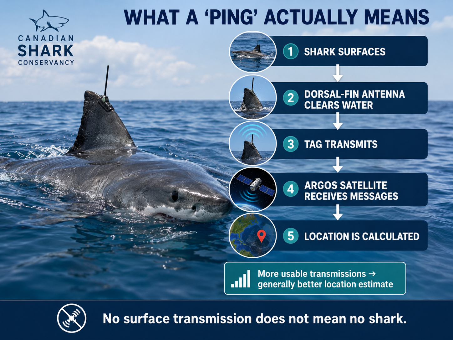
A commonly used SPOT — Smart Position and Temperature — tag transmits to the Argos satellite system when the shark's dorsal fin breaks the surface.
Several things must happen.
The shark has to surface.
The antenna must clear the water.
A compatible satellite must be overhead.
And the antenna ideally needs to remain exposed long enough for the satellite to receive multiple transmissions.
More transmissions generally mean a better position estimate.
If the shark surfaces for only a moment?
The satellite may receive too little information for a high-quality fix.
If the shark remains submerged?
There is no satellite position.
If it surfaces while no suitable satellite is in position?
Again, no location.
So the appearance of a dot means something quite specific:
The tag successfully communicated with a satellite during a surfacing event.
It does not mean:
The shark was continuously tracked until that moment.
No surface transmission does not mean no shark.
Not Every Dot Is Equally Accurate
This is where things become especially interesting.
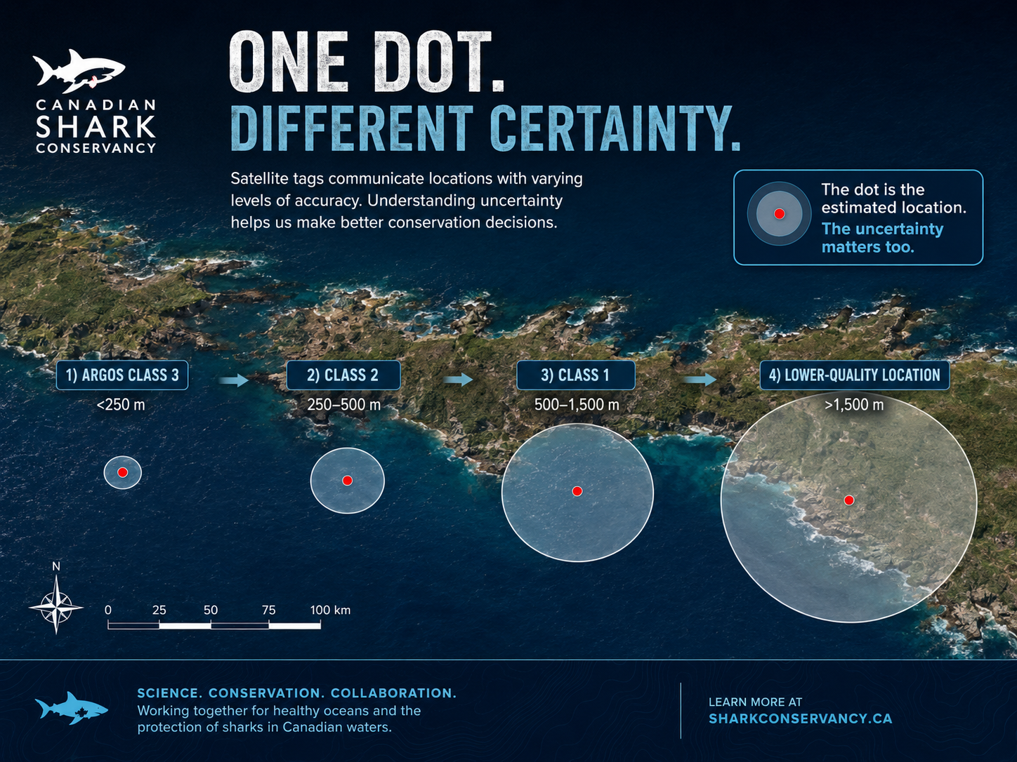
The Argos system assigns locations different quality classes.
For conventional Doppler-derived locations, its published accuracy categories include:
Class 3: error radius less than approximately 250 metres
Class 2: approximately 250–500 metres
Class 1: approximately 500–1,500 metres
Class 0: error greater than 1,500 metres
Other classes can be generated when too few messages are received to estimate accuracy conventionally.
Think about what that means visually.
A tracking website may place one little icon on a map.
But scientifically, the better mental picture may be:
a point surrounded by an uncertainty area.
For a high-quality location, that area may be relatively small.
For a poor-quality location, the shark could have been a considerable distance from the displayed point.
And that explains one of the strangest things people sometimes see on shark trackers.
No, the Shark Did Not Walk Across Nova Scotia
Occasionally a satellite-tracking point appears on land.
That makes for an entertaining screenshot.
But the explanation is usually much less revolutionary than the discovery of a terrestrial great white.
The Shark Research Foundation explains that when a shark surfaces only briefly, too few transmissions may be received to calculate a highly precise position. Near a coastline, that error can place the estimated location on the wrong side of the shoreline—even though the animal remained in the ocean.
So:
A tracking point on land does not mean the shark was on land.
It may mean:
The real location was offshore, but the uncertainty around the calculated satellite position overlapped the coast.
This is a wonderful example of why maps should be read as scientific products rather than literal photographs of movement.
Then Scientists Start Cleaning the Track
Raw telemetry is not simply downloaded and immediately published as truth.
Researchers evaluate it.
In the major western North Atlantic white-shark telemetry study we have used throughout this series, scientists filtered SPOT locations before analysis.
They removed positions:
with inadequate error information,
that appeared on land,
and that would require the shark to have moved at an unrealistic speed relative to the previous reliable position.
For that study, researchers applied a swimming-speed filter of 3 metres per second to identify implausible locations.
That illustrates an important part of science that rarely makes it onto a public tracking map.
Data require judgement.
Not judgement in the sense of simply deciding which results researchers like.
Judgement based on known measurement error, animal biology and explicit analytical rules.
A calculated location that would require a shark to teleport across a continent does not become biologically meaningful simply because a satellite produced coordinates.
The Straight Line Is Not the Shark’s Route
Now imagine two reliable positions.
Monday:
Nova Scotia.
Thursday:
farther southwest.
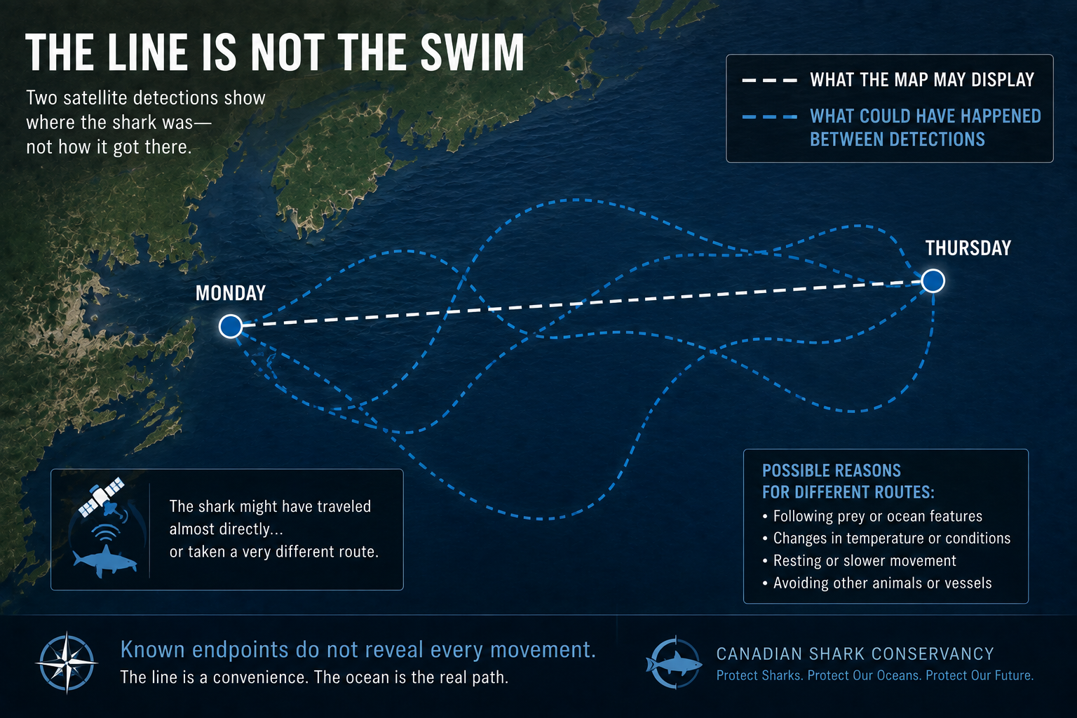
A tracking map draws a line between them.
What happened during the intervening three days?
We don't know exactly.
The shark might have travelled almost directly.
It might have moved offshore.
Returned inshore.
Changed direction.
Dived hundreds of metres.
Followed a shelf edge.
Stopped in a productive area.
Or covered substantially more distance than the straight line suggests.
Unless other data fill the gap, the line tells us only:
the shark was recorded here—and later recorded there.
The connecting line is often a visual convenience.
It is not necessarily the animal's actual path.
This becomes especially important when people calculate apparent swimming speeds or declare that a shark “went straight toward” a particular location.
Sometimes it may have.
But two endpoints alone cannot prove the journey between them.
Silence Is Data Too—but It Is Not Absence
A shark tracker has been updating regularly.
Then suddenly:
nothing.
A day passes.
A week.
Perhaps longer.
What happened?
The natural reaction is:
Where did the shark go?
But tracking silence can have many explanations.
The animal may simply remain below the surface.
The tag may surface when no suitable satellite is available.
The antenna may not remain exposed long enough.
The tag may become fouled.
The battery may weaken.
The transmitter may be damaged.
The tag may detach.
Or eventually, the tag may cease functioning.
The Shark Research Foundation specifically warns that sharks can go long periods without producing satellite positions simply because they do not surface in a way that allows successful transmission.
This creates one of the most fundamental principles of wildlife telemetry:
No detection does not necessarily mean no animal.
The absence of a signal is not automatically evidence that the shark left.
What a Missing Signal Can Mean
SHARK BEHAVIOUR The animal stayed submerged.
SATELLITE OPPORTUNITY No appropriate pass occurred during surfacing.
TRANSMISSION QUALITY The fin surfaced too briefly.
TAG CONDITION Fouling, damage or battery limitation.
TAG LOSS The device detached.
TRUE ABSENCE The shark really did leave the monitored area.
The last explanation is only one possibility.
That distinction becomes even more important when we move from satellites to underwater listening stations.
An Acoustic Receiver Does Not See the Shark
Acoustic telemetry solves one satellite problem.
The shark does not need to surface.
An implanted acoustic transmitter emits an individually coded sound signal.
If the shark swims within usable range of a compatible receiver, the receiver records:
the transmitter identity,
the date,
the time,
and potentially sensor data carried by the transmission. Canada's Ocean Tracking Network commonly places receivers in arrays or “listening lines,” with stations often spaced roughly 800 metres apart, although array design varies by research question and environment.
That can produce extremely valuable evidence.
If a receiver positioned in Cabot Strait detects shark MA1234 at 03:17 on September 12, scientists know that animal came within detection range of that station at that time.
But notice what we did not say.
We did not say the shark was exactly at the receiver.
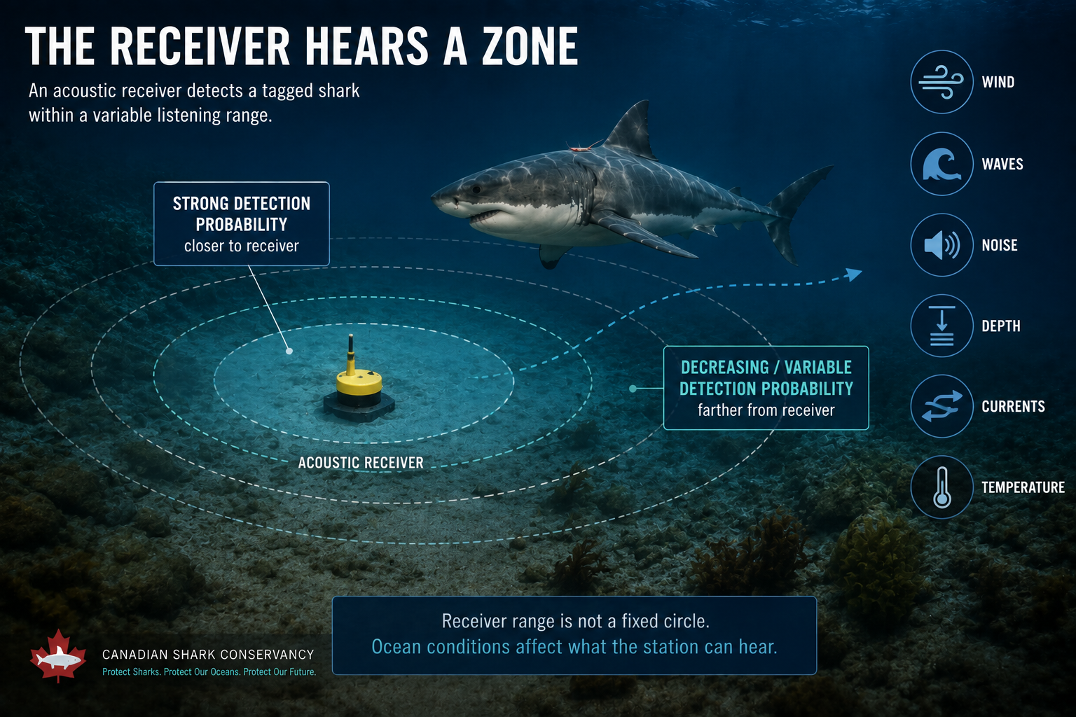
The receiver hears a zone around itself.
How Far Away Can a Receiver Hear?
There is no universal answer.
Sometimes you will see simple estimates of several hundred metres.
CSIRO, for example, notes that its shark acoustic systems commonly require animals to pass within roughly 500 metres of a listening station, while Ocean Tracking Network material describes receivers detecting animals within the effective range of the local installation.
But underwater sound propagation changes with conditions.
Detection can be affected by:
wind,
waves,
background noise,
currents,
water depth,
temperature,
receiver orientation,
seafloor structure,
and other environmental characteristics.
Studies of marine acoustic arrays have found detection performance varying enormously—even from less than 50 metres to as much as 1,500 metres in different conditions and configurations.
That means an acoustic detection is best understood as:
A confirmed encounter with the listening zone.
Not:
A GPS coordinate for the animal.
And Again: No Detection Does Not Prove Absence
Imagine a listening line with receivers spread across a passage.
A tagged shark crosses and is detected.
Excellent.
Now another shark produces no detection.
Did it fail to cross?
Possibly.
But perhaps:
it crossed outside the array,
passed through a gap,
moved beyond effective listening range,
crossed during poor detection conditions,
or its acoustic tag was no longer operating.
For this reason, many acoustic studies treat detections conservatively as presence data.
A detection can strongly establish that an animal was there.
A non-detection is usually much harder to interpret.
A white-shark telemetry study explicitly treated collaborative acoustic positions as presence-only information because detection and reporting effort varied across the network.
There is an important asymmetry here:
Detection = strong evidence of presence.
No detection ≠ equally strong evidence of absence.
The Most Mysterious Track Comes From a Tag That Leaves the Shark
Now consider the Pop-up Satellite Archival Tag — PSAT.
This device provides extraordinary information precisely because it does not depend upon the dorsal fin repeatedly surfacing.
The tag travels with the shark while recording variables such as:
depth,
temperature,
light,
and time.
Then, on a programmed date—or under certain programmed conditions—it releases.
The tag floats upward.
Reaches the surface.
And transmits stored information to Argos satellites.
The result can reveal the shark's vertical life in extraordinary detail.
But the horizontal track presents another challenge.
Because for much of the deployment, the tag did not know its position in the GPS-like sense people often imagine.
Scientists have to estimate it.
Finding Location From Light
One clue comes from daylight.
A PSAT can record changing ambient light levels.
Approximate sunrise and sunset timing can provide information about longitude and latitude.
But underwater light is messy.
Cloud.
Depth.
Turbidity.
Animal behaviour.
Season.
All can influence the light record.
And latitude estimation becomes particularly difficult around the equinoxes because day length becomes similar over broad areas.
This means raw light-based location estimates can contain substantial uncertainty.
For the western North Atlantic white-shark study, the authors noted that light-derived PSAT positions can have errors on the scale of roughly 80–150 kilometres.
Eighty kilometres.
One hundred and fifty kilometres.
That is not the little dot many people imagine when they hear “satellite tag.”
So scientists add more information.
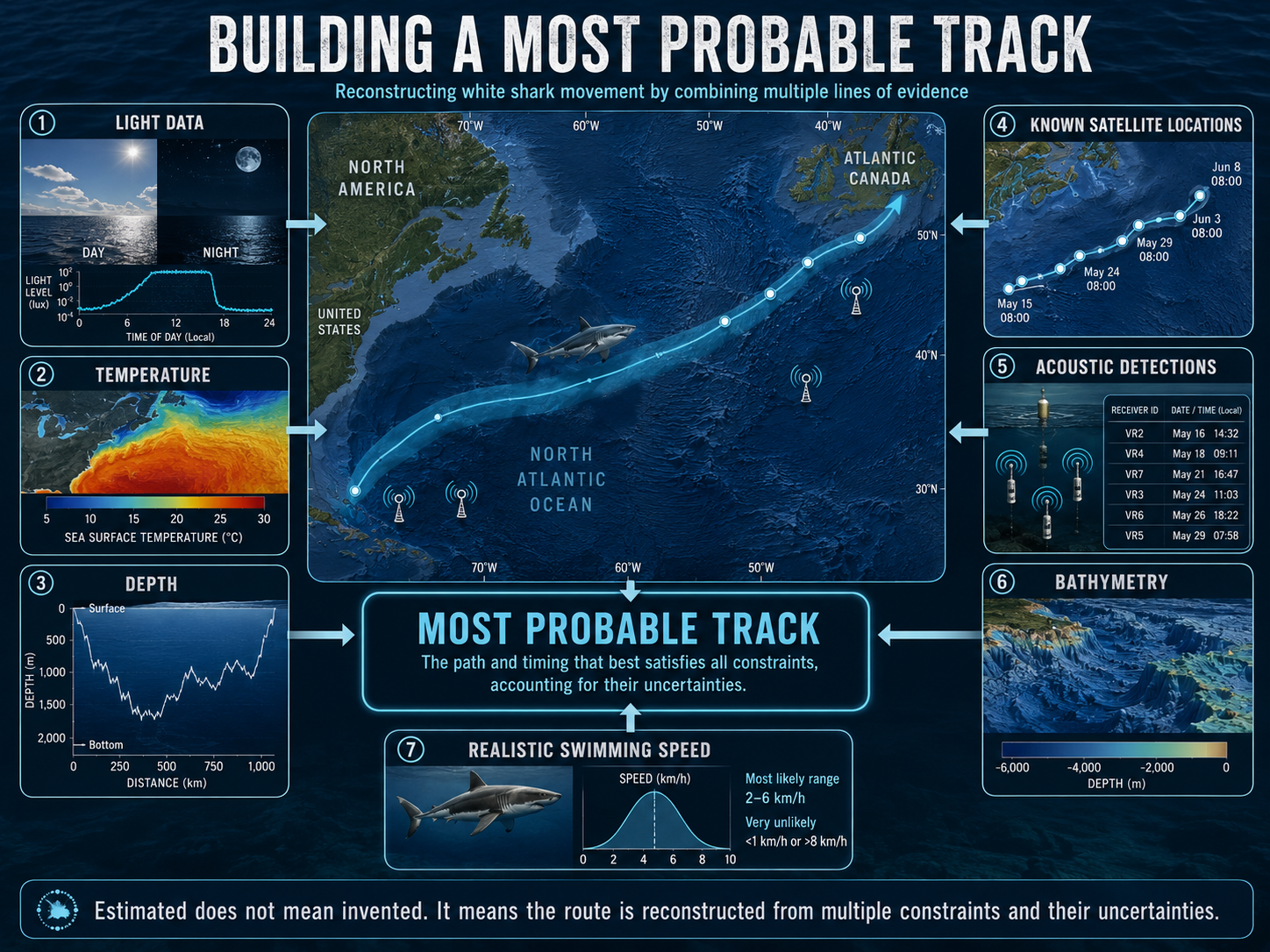
Reconstructing the Most Probable Track
Researchers may combine the tag's light estimates with:
sea-surface temperature,
bathymetry,
known satellite positions,
acoustic detections,
realistic swimming speeds,
and mathematical movement models.
The question becomes:
Given everything we know, which path through the ocean is most consistent with all of these observations?
That produces what is often called a:
Most Probable Track
The wording matters.
Not:
THE EXACT TRACK.
But:
THE MOST PROBABLE TRACK.
In the major western North Atlantic study, higher-accuracy acoustic and SPOT locations were incorporated into PSAT models to improve the estimated pathways.
This is a beautiful example of several imperfect measurement systems making one another stronger.
Satellite locations constrain the track.
Acoustic detections anchor it.
Depth rules out impossible bathymetry.
Temperature helps match ocean regions.
Swimming speed prevents biologically impossible jumps.
Mathematics integrates them.
The final track is not guesswork.
But neither is it a continuous GPS recording.
It is scientific inference built from evidence.
Sometimes the Tag Comes Home
There is another fascinating feature of PSATs.
Normally, after the tag surfaces, only a limited amount of summarized data can be transmitted through the satellite system before battery life and communications constraints intervene.
But if researchers physically recover the tag, they may gain access to the much richer archive stored onboard.
Wildlife Computers notes that PSATs archive data internally while sending only a subset or summary by satellite after pop-up; full-resolution information can become available when a tag is physically recovered.
That explains why the recovery of a tag floating somewhere in an enormous ocean can be scientifically valuable.
In early 2026, OCEARCH reported recovering multiple PSATs previously deployed on white sharks—allowing researchers access to richer datasets about the animals' depth, temperature and movement histories.
Sometimes a small instrument retrieved from the sea can contain months of hidden shark life.
A Photograph Has Blind Spots Too
Technology does not have to contain a battery.
A photograph can also track a shark.
Distinctive features can identify individuals:
dorsal-fin shape,
pigmentation,
scars,
injuries,
body markings.
If the same animal is photographed off Nova Scotia again two years later, that image can establish survival and return without any electronic tag transmitting.
But photography has its own sampling problem.
A shark must:
be encountered,
be photographed,
be photographed at a useful angle,
and be successfully matched.
If it is not photographed next year, that does not prove it failed to return.
Perhaps nobody encountered it.
Perhaps the water was poor.
Perhaps the photograph was unusable.
Perhaps it used another section of coast.
Every method has a window.
Every window leaves part of the ocean unseen.
Even the Sharks We Tag Can Bias the Story
There is one more layer of uncertainty that is less obvious.
Which sharks got tagged in the first place?
Researchers cannot randomly select white sharks from the entire western North Atlantic population as if drawing names from a hat.
Tags are deployed where researchers can safely and successfully encounter sharks.
That means tagging effort is geographically uneven.
The major Canadian analysis led by DFO's Heather Bowlby examined 272 tag deployments, but the authors noted that much of the tagging effort occurred around Cape Cod, where white sharks gather seasonally around recovering pinniped populations.
Interestingly, sharks tagged in different regions did not all show identical probabilities of moving to Canada. In that study, 13 of 25 sharks tagged off South Carolina later used Canadian waters, compared with 35 of 119 tagged off Cape Cod. The researchers therefore cautioned that different components of the population may use different movement strategies.
That is a major lesson.
A tracking dataset tells us about the animals represented in the dataset.
Scientists then have to determine how confidently those animals represent the whole population.
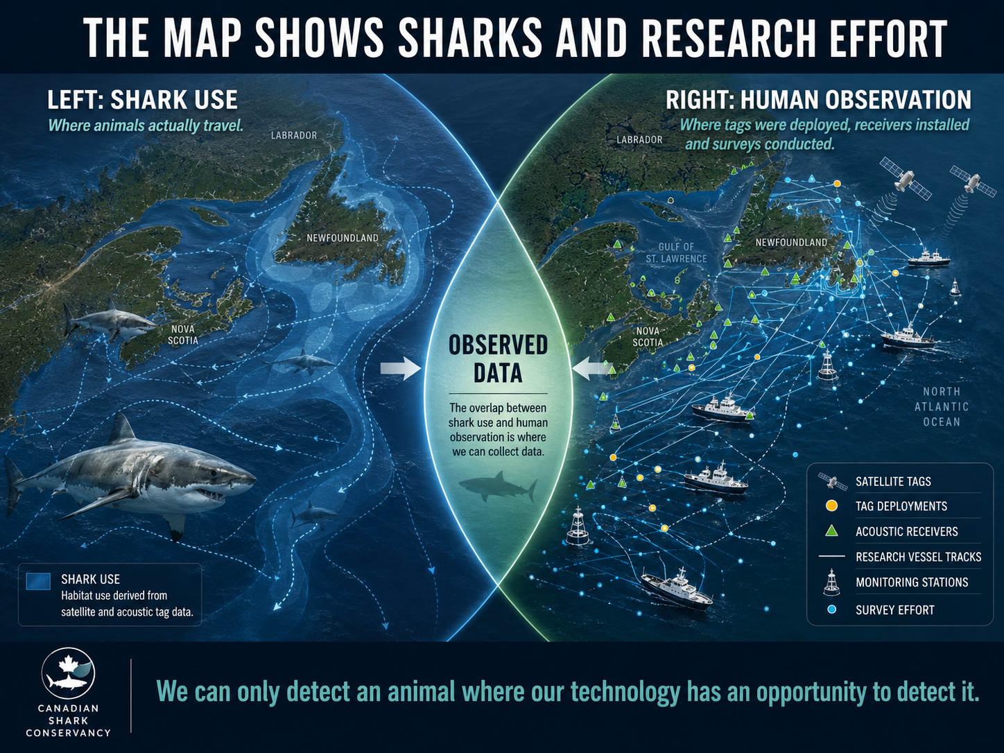
The Map Also Shows Where Humans Looked
This is especially important for acoustic monitoring.
Canadian listening effort has not been equally distributed everywhere.
The 2022 analysis found the greatest acoustic monitoring effort along Nova Scotia's Atlantic coast, with less effort in the Bay of Fundy and Gulf of St. Lawrence and still less off Newfoundland and Labrador.
So if a map shows far more acoustic detections around Nova Scotia than Newfoundland, there are at least two possible explanations:
More sharks used Nova Scotia.
or
Scientists listened more intensely in Nova Scotia.
Possibly both.
Good research tries to separate ecological patterns from sampling patterns.
That is why the receiver network itself must be part of how the shark map is interpreted.
This Does Not Make Tracking Unreliable
After everything we have just discussed, it would be easy to arrive at exactly the wrong conclusion.
Satellite points have error.
Acoustic receivers have variable detection zones.
PSAT tracks are estimated.
Tags fail.
Animals go undetected.
Sampling effort is uneven.
So is tracking unreliable?
No.
This is how science works.
Reliability does not come from pretending uncertainty does not exist.
Reliability comes from:
measuring it,
quantifying it,
reporting it,
testing assumptions,
filtering erroneous observations,
combining independent methods,
and restricting conclusions to what the evidence can support.
The major western North Atlantic white-shark work is powerful precisely because researchers combined satellite, archival and acoustic telemetry across multiple years and dozens—or, in the Canadian analysis, hundreds—of tag deployments.
One imperfect observation tells us little.
Hundreds of observations, gathered through different systems and repeatedly pointing toward the same ecological pattern, tell us considerably more.
That is how we know white sharks migrate north.
How we know some enter Canada.
How we know some return.
How we identify seasonal residency.
And how the blank spaces on the map gradually become smaller.
Read a Shark Tracker Like a Scientist
The next time you open a shark-tracking map, try asking different questions.
Instead of:
“Where is the shark?”
Ask:
“What kind of detection produced this point?”
Instead of:
“Why did it swim in that straight line?”
Ask:
“How much time passed between those locations?”
Instead of:
“Why hasn't it moved in a week?”
Ask:
“Has the tag simply failed to produce another detection?”
Instead of:
“Why is the shark on land?”
Ask:
“What is the uncertainty associated with that satellite location?”
Instead of:
“There are no detections here, so there must be no sharks.”
Ask:
“Was anyone actually listening there?”
That is the difference between watching dots and reading evidence.
A Dot Becomes Science Only in Context
Return to our original white shark off Nova Scotia.
The dorsal fin breaks the surface.
For a few seconds, its tag reaches sky.
A satellite hears it.
A coordinate is calculated.
Another point appears three days later.
Months afterward, an acoustic receiver detects the same shark.
The following year, another signal appears near Nova Scotia.
Now the pattern begins to change.
One point tells us:
the shark was probably here.
An acoustic detection tells us:
it passed this listening station.
A PSAT tells us:
it used these depths and temperatures.
A second year tells us:
it came back.
Another shark doing the same thing tells us:
perhaps this is not coincidence.
Dozens of sharks begin revealing:
a population pattern.
That progression—from signal to pattern—is where telemetry becomes ecology.
The Uncertainty Is Part of the Discovery
There is something almost appropriate about the fact that shark tracking contains gaps.
White sharks spend most of their lives beyond our sight.
We have built remarkable technologies capable of following pieces of those lives across oceans.
But the animal still retains some of its mystery.
The blank spaces matter.
Not because they defeat the science.
Because they tell scientists what must be learned next.
Where should another receiver go?
Which sharks are missing from the sample?
Which tracking technology should be combined with another?
Which habitat deserves closer investigation?
Where is the uncertainty too large to support a conservation decision?
In that sense, every imperfect track is doing two things.
It tells us something about the shark.
And it tells us something about the limits of our ability to observe it.
Good science respects both.
We Are Not Watching the Shark
We are reconstructing its life.
A signal reaches a satellite.
A sound reaches a receiver.
A sensor records cold water 300 metres beneath the surface.
A photograph matches a dorsal fin photographed years before.
A tag pops free somewhere thousands of kilometres away.
Each event is incomplete.
But together they begin forming something extraordinary.
A migration.
A seasonal range.
A returning individual.
A Canadian habitat.
And eventually, perhaps, enough evidence to understand which places matter enough to protect.
The tracking map is not the shark.
It never was.
It is something almost as remarkable:
our growing ability to hear an animal moving through an ocean that once made it disappear.
They don't live in Canada.
They return to Canada.
And every year, we are getting a little better at understanding the signals they leave behind.
NEXT — PART 7
Who Comes North?
Why young white sharks may be especially important to Canada's story
Not every western North Atlantic white shark migrates into Canadian waters.
And the sharks that do come north do not appear to represent every life stage equally.
Canadian telemetry research found that tagged juveniles and subadults were substantially more likely to be detected in Canadian waters than tagged adults.
Why?
Does Atlantic Canada provide particularly valuable habitat for growing sharks?
How do diets and movement change as a white shark matures?
Where are the largest adult females?
And what does the age structure of Canada's seasonal visitors tell us about the role Canadian waters may play in the life of the wider Northwest Atlantic population?
Part 7 asks a deceptively simple question:
Which white sharks are actually coming to Canada?